Show the map
Forêt de Fausses Reposes - Parc de Saint Cloud
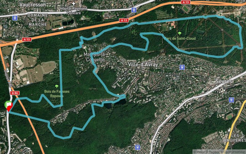


16.5 km
280 m
280 m
 Marnes-la-Coquette (92)
 Points of Interest table
| Accum. | Intermediary | |||||||
|---|---|---|---|---|---|---|---|---|
| POI | Description | Alt. | Dist. | D+ | D- | Dist. | D+ | D- |
Trace n°50278
Ascent threshold : 3 m Distance threshold : 30 m Smoothing : Yes Origin of altitudes : MNT IGN
Ascent threshold : 3 m Distance threshold : 30 m Smoothing : Yes Origin of altitudes : MNT IGN
Loop
Dominant terrain : Footpath
Max alti. : 177 m
Avg alti. : 134 m
Min alti. : 56 m
Longest ascent : 120 m
Longest descent : 110 m
Route completed by the author : No
Dominant terrain : Footpath
Max alti. : 177 m
Avg alti. : 134 m
Min alti. : 56 m
Longest ascent : 120 m
Longest descent : 110 m
Route completed by the author : No
Elevation profile
More tools
Create a new roadbook page
Map and track on your website
Warning ! When you insert a Trace de Trail map on your website, you agree not to hide any element of the module (links to Trail Trail or Trail Connect banner)
Add a realisation
Validate
Add a realisation to share your chrono and describe the conditions that you encountered during you trail running !
Add a comment
Validate
Joffs
22/06/22, 11:39:22
Beau parcours. Dénivelé plus proche de 300 mais gros problème sur la fin (vers le 13eme km) pour rejoindre la trace avec mur infranchissable car certainement portes murées depuis. Obligé de passer par le pont de l’A13 …
22/06/22, 11:39:22
Beau parcours. Dénivelé plus proche de 300 mais gros problème sur la fin (vers le 13eme km) pour rejoindre la trace avec mur infranchissable car certainement portes murées depuis. Obligé de passer par le pont de l’A13 …
Show the infos
Add a track


