Show the map
OFFICIAL ROUTE
Trail étoilé d'Orcières 2024 - 9 km
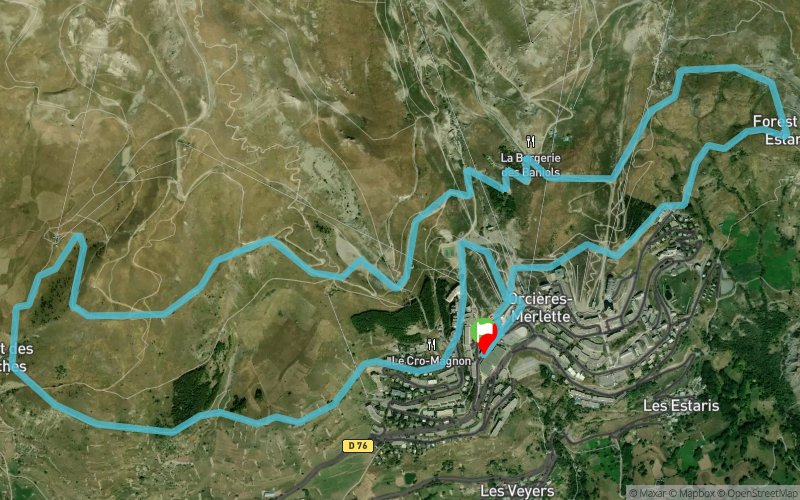


8.8 km
460 m
460 m
 Orcières (05)
 Points of Interest table
| Accum. | Intermediary | |||||||
|---|---|---|---|---|---|---|---|---|
| POI | Description | Alt. | Dist. | D+ | D- | Dist. | D+ | D- |
 Competition organized on 01/13/2024
Trace n°72002
Ascent threshold : 3 m Distance threshold : 30 m Smoothing : Yes Origin of altitudes : MNT Aster GDEM
Ascent threshold : 3 m Distance threshold : 30 m Smoothing : Yes Origin of altitudes : MNT Aster GDEM
Loop
Dominant terrain : Path
Max alti. : 2043 m
Avg alti. : 1927 m
Min alti. : 1824 m
Longest ascent : 150 m
Longest descent : 160 m
Dominant terrain : Path
Max alti. : 2043 m
Avg alti. : 1927 m
Min alti. : 1824 m
Longest ascent : 150 m
Longest descent : 160 m
Elevation profile
More tools
Create a new roadbook page
Map and track on your website
Warning ! When you insert a Trace de Trail map on your website, you agree not to hide any element of the module (links to Trail Trail or Trail Connect banner)
Add a realisation
Validate
Add a realisation to share your chrono and describe the conditions that you encountered during you trail running !
Add a comment
Validate
Admin - Trace de Trail
04/10/19, 19:51:10
Bonjour, Merci de créer une nouvelle trace pour l'édition 2020.
04/10/19, 19:51:10
Bonjour, Merci de créer une nouvelle trace pour l'édition 2020.
Show the infos
Add a track


