Show the map
Evaluated Track - ITRA
Vu?ko Trail 2019 - 13 km
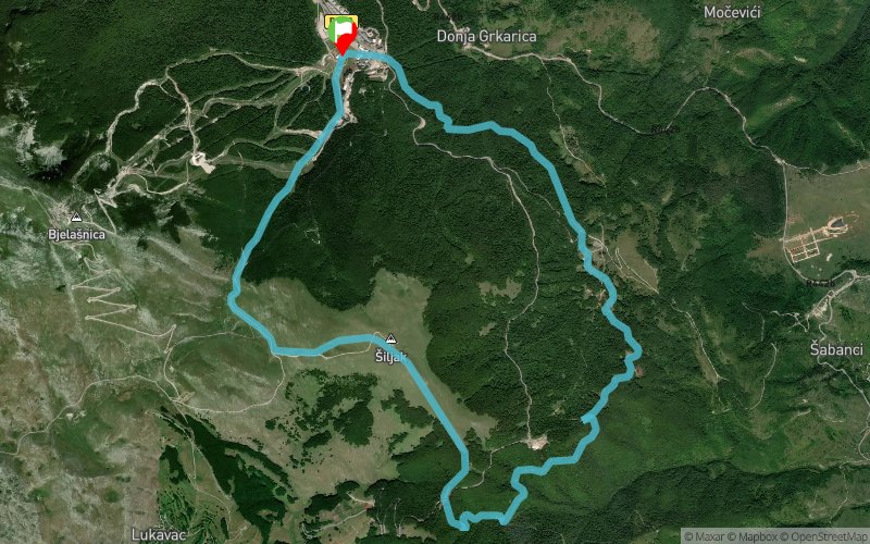


13.1 km
640 m
640 m
 Gornji Vinjani (HR)
 6
6
A relaxed trail for everyone and anyone, without much elevation gain and with pleasant environment and route. The trail is runnable, but it also provides for a more classical hiking approach and enables participants to fully enjoy the nature in a relaxed circular route. For all those who would like to try but believe they can’t do it, but also for those who see such distances as competitive or just want to do a somewhat more demanding workout.
Points of Interest table
| Accum. | Intermediary | |||||||
|---|---|---|---|---|---|---|---|---|
| POI | Description | Alt. | Dist. | D+ | D- | Dist. | D+ | D- |
 Competition organized on 06/23/2018
Trace n°61396
Ascent threshold : 3 m Distance threshold : 30 m Smoothing : No Origin of altitudes : MNT Aster GDEM
Ascent threshold : 3 m Distance threshold : 30 m Smoothing : No Origin of altitudes : MNT Aster GDEM
Loop
Dominant terrain : Path
Max alti. : 1661 m
Avg alti. : 1390 m
Min alti. : 1245 m
Longest ascent : 410 m
Longest descent : 620 m
Dominant terrain : Path
Max alti. : 1661 m
Avg alti. : 1390 m
Min alti. : 1245 m
Longest ascent : 410 m
Longest descent : 620 m
More tools
Create a new roadbook page
Map and track on your website
Warning ! When you insert a Trace de Trail map on your website, you agree not to hide any element of the module (links to Trail Trail or Trail Connect banner)
Add a realisation
Validate
Add a realisation to share your chrono and describe the conditions that you encountered during you trail running !
Add a comment
Validate
Show the infos
Add a track


