Show the map
Mont Caume - Col des Morts - Le Coudon
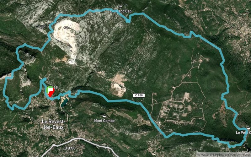


30.2 km
1610 m
1610 m
 Le Revest-les-Eaux (83)
 Points of Interest table
| Accum. | Intermediary | |||||||
|---|---|---|---|---|---|---|---|---|
| POI | Description | Alt. | Dist. | D+ | D- | Dist. | D+ | D- |
Trace n°61020
Ascent threshold : 3 m Distance threshold : 0 m Smoothing : No Origin of altitudes : GPS
Ascent threshold : 3 m Distance threshold : 0 m Smoothing : No Origin of altitudes : GPS
Loop
Dominant terrain : Footpath
Max alti. : 776 m
Avg alti. : 489 m
Min alti. : 127 m
Longest ascent : 540 m
Longest descent : 550 m
Route completed by the author : Yes
Dominant terrain : Footpath
Max alti. : 776 m
Avg alti. : 489 m
Min alti. : 127 m
Longest ascent : 540 m
Longest descent : 550 m
Route completed by the author : Yes
Elevation profile
More tools
Create a new roadbook page
Map and track on your website
Warning ! When you insert a Trace de Trail map on your website, you agree not to hide any element of the module (links to Trail Trail or Trail Connect banner)
Add a realisation
Validate
Add a realisation to share your chrono and describe the conditions that you encountered during you trail running !
Add a comment
Validate
ced63
30/12/18, 22:22:43
Trace pas toujours évidente à suivre, parfois hors sentiers, certains passages assez techniques (chemin difficile à trouver au sommet du mont Caume car il y a une petite dé-escalade à effectuer au niveau de l'éperon rocheux, passage dans des petits pierriers et sur des rochers rappelant les lapiaz). Donc attention sortie d'un assez bon niveau. Bonne trace en préparation de trails techniques.
Show the infos
Add a track


