Show the map
Mont d'Autuche - Col de la Croix
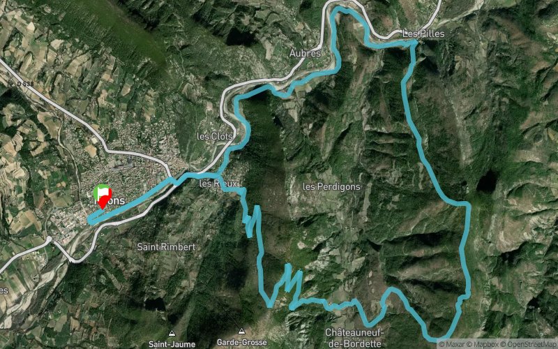


27.3 km
1115 m
1108 m
 Nyons (26)
 Points of Interest table
| Accum. | Intermediary | |||||||
|---|---|---|---|---|---|---|---|---|
| POI | Description | Alt. | Dist. | D+ | D- | Dist. | D+ | D- |
Trace n°5427
Ascent threshold : 3 m Distance threshold : 30 m Smoothing : Yes Origin of altitudes : MNT Aster GDEM
Ascent threshold : 3 m Distance threshold : 30 m Smoothing : Yes Origin of altitudes : MNT Aster GDEM
Loop
Dominant terrain : Footpath
Max alti. : 941 m
Avg alti. : 487 m
Min alti. : 251 m
Longest ascent : 653 m
Longest descent : 547 m
Route completed by the author : nc
Dominant terrain : Footpath
Max alti. : 941 m
Avg alti. : 487 m
Min alti. : 251 m
Longest ascent : 653 m
Longest descent : 547 m
Route completed by the author : nc
Elevation profile
More tools
Create a new roadbook page
Map and track on your website
Warning ! When you insert a Trace de Trail map on your website, you agree not to hide any element of the module (links to Trail Trail or Trail Connect banner)
Add a realisation
Validate
Add a realisation to share your chrono and describe the conditions that you encountered during you trail running !
Add a comment
Validate
Sébastien Tch
18/05/20, 18:25:14
Parcours super cool, dommage que les crêtes sur la première partie monté
18/05/20, 18:25:14
Parcours super cool, dommage que les crêtes sur la première partie monté
More comments
Show the infos
Add a track


