Show the map
Merville - ATR
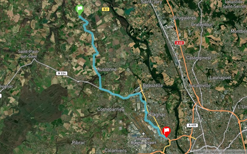


19.6 km
176 m
187 m
 Merville (31)
 Blagnac (31)
 Points of Interest table
| Accum. | Intermediary | |||||||
|---|---|---|---|---|---|---|---|---|
| POI | Description | Alt. | Dist. | D+ | D- | Dist. | D+ | D- |
Trace n°484
Ascent threshold : 0 m Distance threshold : 35 m Smoothing : Yes Origin of altitudes : MNT Aster GDEM
Ascent threshold : 0 m Distance threshold : 35 m Smoothing : Yes Origin of altitudes : MNT Aster GDEM
Crossing
Dominant terrain : Footpath
Max alti. : 161 m
Avg alti. : 143 m
Min alti. : 122 m
Longest ascent : 56 m
Longest descent : 46 m
Route completed by the author : nc
Dominant terrain : Footpath
Max alti. : 161 m
Avg alti. : 143 m
Min alti. : 122 m
Longest ascent : 56 m
Longest descent : 46 m
Route completed by the author : nc
Elevation profile
More tools
Create a new roadbook page
Map and track on your website
Warning ! When you insert a Trace de Trail map on your website, you agree not to hide any element of the module (links to Trail Trail or Trail Connect banner)
Add a realisation
Validate
Add a realisation to share your chrono and describe the conditions that you encountered during you trail running !
Add a comment
Validate
Benoit Brault
10/07/20, 11:35:12
Dommage manque le retour j'ai coupé arrivé à Blagnac Le tour d'airbus revenir sur la piste cyclable direction Mondonville puis Daux part les champs Merci pour la découverte
10/07/20, 11:35:12
Dommage manque le retour j'ai coupé arrivé à Blagnac Le tour d'airbus revenir sur la piste cyclable direction Mondonville puis Daux part les champs Merci pour la découverte
Show the infos
Add a track


