Show the map
Mespel - St-Martin - Pont Bourguet
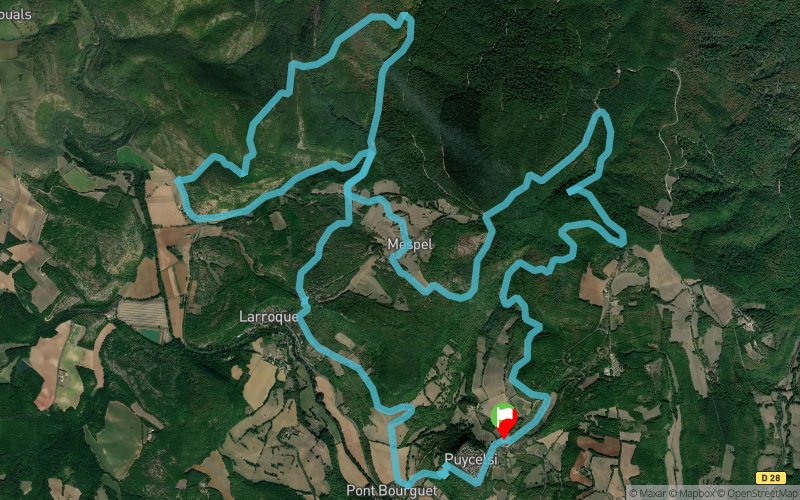


21.5 km
950 m
950 m
 Puycelsi (81)
 Points of Interest table
| Accum. | Intermediary | |||||||
|---|---|---|---|---|---|---|---|---|
| POI | Description | Alt. | Dist. | D+ | D- | Dist. | D+ | D- |
Trace n°42423
Ascent threshold : 3 m Distance threshold : 30 m Smoothing : Yes Origin of altitudes : MNT Aster GDEM
Ascent threshold : 3 m Distance threshold : 30 m Smoothing : Yes Origin of altitudes : MNT Aster GDEM
Loop
Dominant terrain : Path
Max alti. : 373 m
Avg alti. : 256 m
Min alti. : 112 m
Longest ascent : 190 m
Longest descent : 250 m
Route completed by the author : nc
Dominant terrain : Path
Max alti. : 373 m
Avg alti. : 256 m
Min alti. : 112 m
Longest ascent : 190 m
Longest descent : 250 m
Route completed by the author : nc
Elevation profile
More tools
Create a new roadbook page
Map and track on your website
Warning ! When you insert a Trace de Trail map on your website, you agree not to hide any element of the module (links to Trail Trail or Trail Connect banner)
Add a realisation
Validate
Add a realisation to share your chrono and describe the conditions that you encountered during you trail running !
Add a comment
Validate
Benatoulouse
09/02/20, 19:54:00
Chouette parcours, pour la 1ere partie suivre le balisage jaune du sentier du patrimoine.
09/02/20, 19:54:00
Chouette parcours, pour la 1ere partie suivre le balisage jaune du sentier du patrimoine.
Oliv2ler
21/10/19, 20:52:40
Parcours très agréable mêlant GR, circuit du Patrimoine et de rares grands chemins. Un final piquant ;)
21/10/19, 20:52:40
Parcours très agréable mêlant GR, circuit du Patrimoine et de rares grands chemins. Un final piquant ;)
Show the infos
Add a track


