Show the map
Chalet de l'Aulp - La Tournette


 Montmin (74)
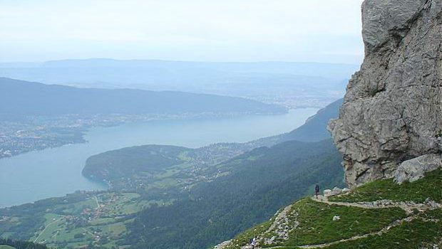
The Tournette is a superb spot to contemplate all the summits above Lake Annecy as well as the Aravis Range and the Mont Blanc Massif, sometimes hidden by the clouds when it’s hot. This ramble is somewhat technical in its final part, as many passages are equipped with cables and chains and, in places, the rock humid and therefore very slippery. I then advise the use of a cord for children.
There are many ibexes in the massif that you can easily approach and photograph. Be careful however as you reach the summit: these same ibexes can trigger rockfalls.
Points of Interest table
| Accum. | Intermediary | |||||||
|---|---|---|---|---|---|---|---|---|
| POI | Description | Alt. | Dist. | D+ | D- | Dist. | D+ | D- |
Trace n°38216
Ascent threshold : 10 m Distance threshold : 30 m Smoothing : Yes Origin of altitudes : MNT Aster GDEM
Ascent threshold : 10 m Distance threshold : 30 m Smoothing : Yes Origin of altitudes : MNT Aster GDEM
Loop
Dominant terrain : Path
Max alti. : 2303 m
Avg alti. : 1844 m
Min alti. : 1428 m
Longest ascent : 540 m
Longest descent : 920 m
Route completed by the author : nc
Dominant terrain : Path
Max alti. : 2303 m
Avg alti. : 1844 m
Min alti. : 1428 m
Longest ascent : 540 m
Longest descent : 920 m
Route completed by the author : nc
Elevation profile
More tools
Create a new roadbook page
Map and track on your website
Warning ! When you insert a Trace de Trail map on your website, you agree not to hide any element of the module (links to Trail Trail or Trail Connect banner)
Add a realisation
Validate
Add a realisation to share your chrono and describe the conditions that you encountered during you trail running !
Add a comment
Validate
Show the infos
Add a track


