Show the map
Certified Track - ITRA
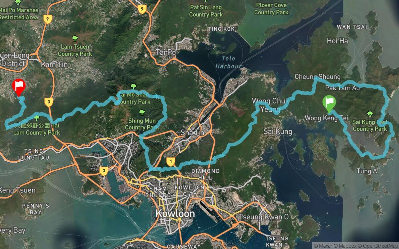
Oxfam Trailwalker Hong Kong 2016


 Inconnu (HK)
 Inconnu (HK)


Points of Interest table
| Accum. | Intermediary | |||||||
|---|---|---|---|---|---|---|---|---|
| POI | Description | Alt. | Dist. | D+ | D- | Dist. | D+ | D- |
 Competition organized on 12/28/2016
Trace n°26374
Ascent threshold : 3 m Distance threshold : 0 m Smoothing : No Origin of altitudes : GPS
Ascent threshold : 3 m Distance threshold : 0 m Smoothing : No Origin of altitudes : GPS
Crossing
Dominant terrain : Road
Max alti. : 951 m
Avg alti. : 328 m
Min alti. : 34 m
Longest ascent : 430 m
Longest descent : 460 m
Dominant terrain : Road
Max alti. : 951 m
Avg alti. : 328 m
Min alti. : 34 m
Longest ascent : 430 m
Longest descent : 460 m
Elevation profile
More tools
Create a new roadbook page
Map and track on your website
Warning ! When you insert a Trace de Trail map on your website, you agree not to hide any element of the module (links to Trail Trail or Trail Connect banner)
Add a realisation
Validate
Add a realisation to share your chrono and describe the conditions that you encountered during you trail running !
Add a comment
Validate
Show the infos
Add a track


