Show the map
L'Escapade d'Ensuès 2015
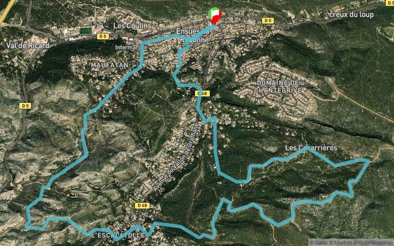


11.9 km
300 m
300 m
 Ensuès-la-Redonne (13)
 Points of Interest table
| Accum. | Intermediary | |||||||
|---|---|---|---|---|---|---|---|---|
| POI | Description | Alt. | Dist. | D+ | D- | Dist. | D+ | D- |
 Competition organized on 11/08/2015
Trace n°14169
Ascent threshold : 3 m Distance threshold : 30 m Smoothing : Yes Origin of altitudes : MNT Aster GDEM
Ascent threshold : 3 m Distance threshold : 30 m Smoothing : Yes Origin of altitudes : MNT Aster GDEM
Loop
Dominant terrain : Path
Max alti. : 201 m
Avg alti. : 104 m
Min alti. : 33 m
Longest ascent : 140 m
Longest descent : 120 m
Dominant terrain : Path
Max alti. : 201 m
Avg alti. : 104 m
Min alti. : 33 m
Longest ascent : 140 m
Longest descent : 120 m
Elevation profile
More tools
Create a new roadbook page
Map and track on your website
Warning ! When you insert a Trace de Trail map on your website, you agree not to hide any element of the module (links to Trail Trail or Trail Connect banner)
Add a realisation
Validate
Add a realisation to share your chrono and describe the conditions that you encountered during you trail running !
Add a comment
Validate
runcisco
08/11/15, 13:58:52
parcours exact de l'escapade d'ensuès la redonne. départ à 9h30 de la place de l'hotel de ville. ravitaillement au km 3,7 et 11. 1km de bitume au départ et 1km a l'arrivée (sortie et entrée du village). environ 300 coureurs.
08/11/15, 13:58:52
parcours exact de l'escapade d'ensuès la redonne. départ à 9h30 de la place de l'hotel de ville. ravitaillement au km 3,7 et 11. 1km de bitume au départ et 1km a l'arrivée (sortie et entrée du village). environ 300 coureurs.
Show the infos
Add a track


