Show the map
Tré le Champ - Aiguillette des Posettes - Le Tour
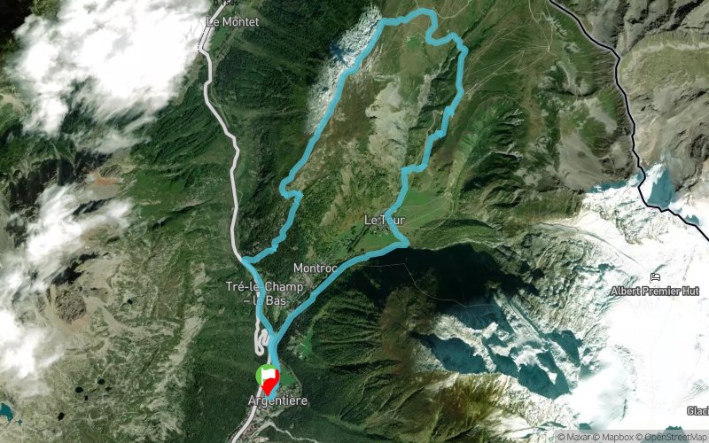


14 km
919 m
920 m
 Argentière (74)
 Points of Interest table
| Accum. | Intermediary | |||||||
|---|---|---|---|---|---|---|---|---|
| POI | Description | Alt. | Dist. | D+ | D- | Dist. | D+ | D- |
Trace n°10571
Ascent threshold : 1 m Distance threshold : 30 m Smoothing : Yes Origin of altitudes : MNT Aster GDEM
Ascent threshold : 1 m Distance threshold : 30 m Smoothing : Yes Origin of altitudes : MNT Aster GDEM
Loop
Dominant terrain : Footpath
Max alti. : 2175 m
Avg alti. : 1666 m
Min alti. : 1255 m
Longest ascent : 923 m
Longest descent : 918 m
Route completed by the author : nc
Dominant terrain : Footpath
Max alti. : 2175 m
Avg alti. : 1666 m
Min alti. : 1255 m
Longest ascent : 923 m
Longest descent : 918 m
Route completed by the author : nc
Elevation profile
More tools
Create a new roadbook page
Map and track on your website
Warning ! When you insert a Trace de Trail map on your website, you agree not to hide any element of the module (links to Trail Trail or Trail Connect banner)
Add a realisation
Validate
Add a realisation to share your chrono and describe the conditions that you encountered during you trail running !
Add a comment
Validate
phch
29/07/18, 17:47:37
Belle boucle débutant par une bonne montée bien relevée, suivie d’une longue descente assez cassante après l’aiguillette en raison des schistes aiguisés comme des couteaux. 2h40 pour un v4.
29/07/18, 17:47:37
Belle boucle débutant par une bonne montée bien relevée, suivie d’une longue descente assez cassante après l’aiguillette en raison des schistes aiguisés comme des couteaux. 2h40 pour un v4.
Show the infos
Add a track


